GSIP 158
Ben Caradoc-Davies
This proposal is for GeoServer 2.12-beta.
- Under Discussion
- In Progress
- Completed
- Rejected
- Deferred
NetCDF/GRIB sources contain rich metadata in the form of variable attributes and extra variables that give meaning to data. When a coverage is read from a NetCDF/GRIB source, this information is lost, even if the output from GeoServer is NetCDF that is capable of representing this information.
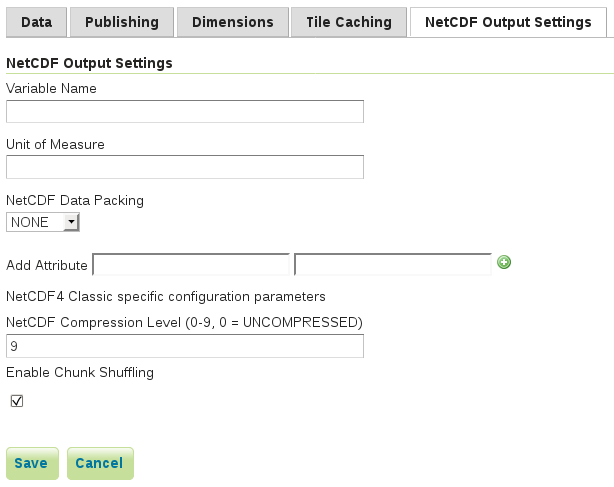
For NetCDF output add:
- An option to allow all attributes to be copied from the source NetCDF/GRIB variable to the target variable
- Support for manual configuration of variable attributes, much like the current support for setting global attributes
- Support for configuration of extra variables which are copied from the NetCDF/GRIB source to the output; initially only scalar variables will be supported
- An option for each extra variable to be expanded over dimensions, that is, values copied from one scalar per ImageMosaic granule are assembled into a multidimensional variable over, for example, time and elevation
Current interface:
Draft of proposed interface:

- Addition of a coverage property
SourceUrlfor GeoTools NetCDF and ImageMosaic readers; this property can be discovered byNetCDFOutputManagerin GeoServer gs-netcdf-out - Implementation of the user interface and settings serialisation in GeoServer gs-netcdf-out
- Implementation of the new variable attribute and extra variable functionality in
NetCDFOutputManagerin GeoServer gs-netcdf-out
The proposed implementation is designed to preserve existing functionality and behaviour. Configuration files that lack the new settings will continue to work as before.
Project Steering Committee:
- Alessio Fabiani:
- Andrea Aime:
- Ben Caradoc-Davies:
- Brad Hards:
- Christian Mueller:
- Ian Turton:
- Jody Garnett:
- Jukka Rahkonen:
- Kevin Smith:
- Simone Giannecchini: